
Belle Fontaine, Old Maps, and the St. Roch Spring
Belle Fontaine
Certain old maps of the coastal area seem to show a “Belle Fontaine” near the Bay of St. Louis. Furthermore, it makes sense that it was located near the Indian mound near the foot of the Highway 90 bridge. The location of a fresh water spring surely would have had great importance in the choice of the site for a settlement by our Native American forerunners.
At the outset, I should state plainly that this is not indisputable. I believe my good friend Marco Giardino has long held that the map placed the location near Bookter Street. His reasoning was partly based on the topography of the area. In addition, he points out that other belle fontaines were noted in different areas on early coastal maps.
Even before the settlement of the area by French and Canadians, an Indian midden was built near the site favored in this article. It is believed by archaeologists who have studied the area that many years ago, there existed around the mound an entire village of a prehistoric culture. A picturesque mound can be observed from the beach road, looking just south of the Breath property. It makes sense that the tribe would have lived near a source of fresh water.
There is also written history. Andre Penicaut, in his Fleur de Lys and Calumet, a copy of which is in the Lobrano House, seems to have confirmed the presence of such a natural flow of water near the spot that eventually became Bay St. Louis. Having travelled with Iberville and Bienville from the beginning of their explorations, he recorded that they “slept at the entrance of the bay, close by a spring of fresh water that flows down from the mountains and that nowadays is called La Belle Fontaine.”
It is expected that a reader may wonder about Penicaut’s “mountains,” but a good guess is that he simply meant higher land, and that the water came down by gravity flow.
A footnote in Penicaut’s history by editor McWilliams gives the meaning of the word “fontaine” to be a “small creek or spring” and refers to D’Anville’s “Carte de la Louisiane.” The historical society’s map book, Charting Louisiana, Five Hundred Years of Maps, plate 24, contains a copy of D’Anville’s 1752 map, clearly showing the location of “Fontaine” at the western side of the bay. Another map indicates the same placement and uses the phrase “Belle Fontaine.”
McWilliams points out that there are other “belle fontaines” at Pascagoula and Mobile, and expresses doubt about the Bay St. Louis location. However, in view of Penicaut’s detailed description of the geography of the area, it is difficult for me to have any second thoughts. What he wrote was as follows: “The next day, leaving Isle-aux-Pois, we passed through some little rigolets, which end up at the sea three leagues away, near Baye de St. Louis.” A careful reading shows that the “little rigolets” was not the main connection between Lakes Pontchartrain and Borgne that today we call the Rigolets, but the mouth of the Pearl River, “whose water is very good to drink.”
1857 Map of Shieldsboro
An important map was added to the collection at the Hancock County Historical Society some time ago by Charles Gray. It may be viewed at the Lobrano House. This map, a wonderfully detailed image of the Bay of St. Louis and Shieldsboro Harbor, was commissioned by the United States government. From this source, a network of canals and natural drainage streams seem to empty into the Mississippi Sound at the same location as above. The delineation of marshes offers a picture of the landscape as nature would have provided it before man-made changes.
A very thin line, apparently representing natural drainage, runs from a marsh area behind the present site of the yacht harbor, underneath present Highway 90, and splits at a point just further south. A roadway is drawn to both sides of the waterway, the whole being shown as being perhaps a quarter mile from the beach.
The important thing, if all this guesswork is accurate, is that the waterway is traced, serpentine, to the immediate west of the Indian mound.
More Maps
The society also possesses some highly accurate maps from the Sanborn Map Company. Two of these are particularly significant, one dated 1904 and the other, 1917. The first of these shows that by 1904 ten artesian wells were being utilized to provide water flowing “along Front Street, Main, Union, and Washington for domestic purposes only.”
The second clearly points to the location of a particular artesian well as being just off the east-west boundary of the von Gohren property. Once more, the evidence is bringing us close to the geographical area of what we believe to have been our Belle Fontaine.
Dr. L.H. von Gohren, according to Along the Gulf, had a beautiful estate named “Villa Quisisana.” It was a health resort “situated on the front street a short pleasant drive or walk from the station near the entrance to the Bay.” It was said that the resort offered “Hydro and Electro Therapeutic treatment…. There were also connected with the Villa, a system of baths of almost every description, medicated and mineral water baths, electric and shower baths, &c….”
One may be intrigued to think of electric baths, but what is certain is that Dr. von Gohren and his clients made great use of water. A large source had to be present; moreover, it was said to be mineral water.
Years later, the main house passed into the possession of the Perkins family. It no longer exists, however, as it was during that time when it had to be demolished for the building of the highway leading to the new Bay of St. Louis bridge.
St. Roch Spring
The image of a fountain suggests a natural spring. While it is surely possible that our natural water source was more a rivulet draining fresh water from far away, a spring has been suggested many years ago by way of a postcard, one of those colorful souvenir-type pieces meant for easy mailing. It is captured, “St. Roch’s Mineral Spring, Bay St. Louis, Miss.” Pictured in an idyllic setting is a small, curving waterway with a shelter near its bend. The surrounding pine forest seems appropriate for our area.
Though attractive, it was more a curiosity than it was an addition to our history. In plain language, no one knew where it would have been. No one could recognize what the photo conveyed to those with long term memories.
Besides, it was accepted that many such old postcards were known to substitute other scenes for that which they purportedly represented.
Emails and Attachments
And now, through the magic of the internet, come two items sent to Eddie Coleman to verify that there was a real, existential, historical St. Roch Mineral Spring.
One is an old photo of three young ladies and a gentleman visiting St. Roch Mineral Spring. Sent by society member Katherine Ohman, the caption identifies the location as “Second Street, behind the Breath property, believed to have been where the Sherwood Heights condos were built.”
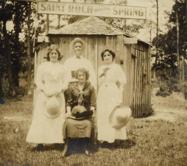 Outing at the St. Roche Mineral Spring
The gentleman in the photo is identified as Ernest Leonhard, and the ladies were possibly “Totsie and Josie” with Missy Breath Altese. Behind them was a small board-and-batten building with shingled roof and a hinged door. Above was a sign, saying in large, clearly legible letters, “SAINT ROCH…SPRING.” It appears that between “Roch” and “Spring” was another word, written in smaller letters, “mineral.”
The building is larger than the usual outhouse of the time, and may well have been a shelter to prevent the spring from freezing in cold weather. In any event, we now have serious evidence that there was indeed a natural spring, a veritable Belle Fontaine, with waters possibly flowing down from distant, higher land.
The second surprise comes from Murella Powell, the distinguished historian and genealogist of the Biloxi Public Library. It consists of several advertisements in New Orleans papers, all in the name of St. Roch Mineral Spring Water. Three ads in the Item were published in 1909, and identify the address as 621 Camp St.
The ads claim “more marvelous cures than any Spring Water Known.” Called “Crescent,” it is said to be bottled “at the spring in Bay St. Louis, Miss.” and is “the most Palatable Water on the market.” Another assurance is that it is “Nature’s Remedy for Stomach, Kidney and Bladder Troubles.” It sold for only 8 cents per gallon, delivered to home or office.
The ad which is more important to our search is dated August 9, 1906, and appeared in the Times Picayune. It reads as follows: “Yesterday was the anniversary of the discovery of St. Roch Spring, and the manager and some friends met and opened a bottle together at the headquarters in Magazine Street. The spring is located at Bay St. Louis and has proven so valuable in quality that large capital is being interested to exploit the property. The bottle had been kept the entire two years, and was still as clear as crystal, with only a slight precipitation of iron, which is one of the constituents of the water.”
It is apparent from the above announcement that the company started business in 1905.
With these copies in hand, I made a trip to the Louisiana Room of the New Orleans Public Library to see what other information might be available. Unfortunately, I found nothing. I also searched on-line and could find only that a Miss Minnie Bowers took some pupils to the spring on May 21, 1905.
It is regrettable that we are unable to tell who the original owners were.
Remaining Question
After all is considered, was the St. Roch Mineral Spring the same as the Belle Fontaine?
A good many years have elapsed between the making of early maps showing a Belle Fontaine and the sale of spring water for 8 cents per gallon. One thing is certain: the spring must have pumped a great volume of water for a going business to be able to capitalize on it.
Over those years, there must have been many facts which might have conclusively identified the location of Bell Fontaine, but regrettably, such information does not easily lend itself to our research. Time, fires, and lack of written history make such locating impossible.
What we do now finally know is that there was in fact such a spring as was given the name “St. Roch Mineral Spring,” and we know at least its general location.
All of that which is described above suggests that a source of fresh water was located somewhere in the vicinity of the rear of the Breath property, and possibly a bit more to the north, where van Gohren’s health resort was located.
So too was the St. Roch Spring.
In summary, one historical fact stands out, that being the site of the Native American settlement and its lovely, still-existing mound. A clear reasoning dictates that those early people would not have founded their village without close access to potable water.
Was then the mound near the Belle Fontaine? We may never know for certain, but what I would like to believe is that site chosen by the entrepreneurs who made an early 20th century business, the location of drinking water on early maps, and the water source of a prehistoric tribe were all the same.
rbg