
This text was obtained via automated optical character recognition.
It has not been edited and may therefore contain several errors.
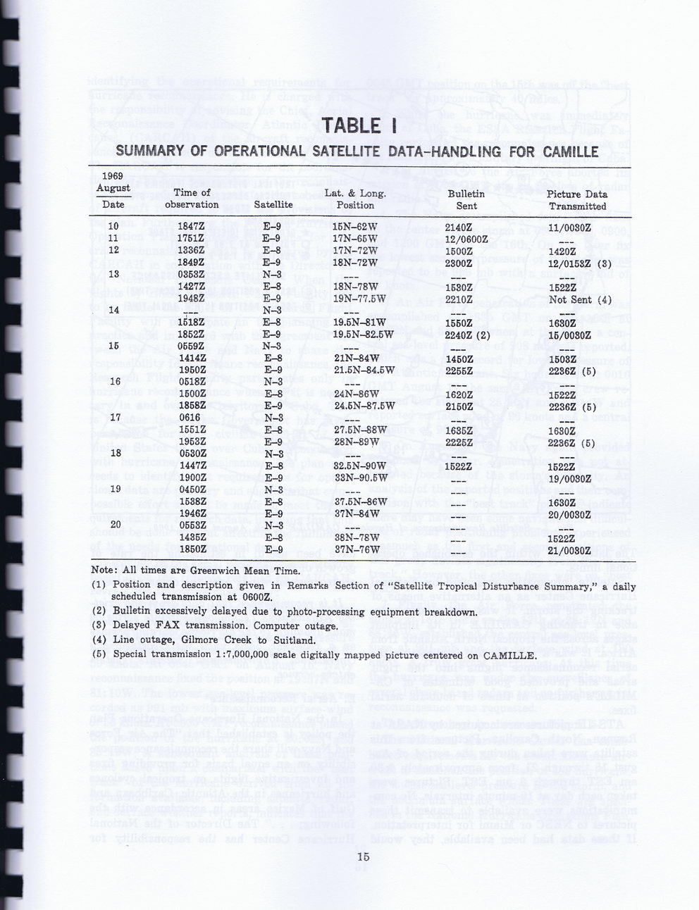
TABLE I
SUMMARY OF OPERATIONAL SATELLITE DATA-HANDLING FOR CAMILLE
1969 August Date	Time of observation	Satellite	Lat. & Long. Position	Bulletin Sent	Picture Data Transmitted
10	1847Z	E-9	1BN-62W	2140Z	11/0030Z
11	1751Z	E-9	17N-65W	12/0600Z
12	1336Z	E-8	17N-72W	1S00Z	1420Z
	1849Z	E-9	18N-72W	2300Z	12/0158Z (3)
13	0353Z	N-3				___
	1427Z	E-8	18N-78W	1530Z	1522Z
	1948Z	E-9	19N-77.BW	2210Z	Not Sent (4)
14	___	N-3
	1518Z	E-8	19.5N-81W	1560Z	1630Z
	1852Z	E-9	19.5N-82.5W	2240Z (2)	16/0080Z
15	06G9Z	N-3		___
	1414Z	E-8	21N-84W	1450Z	1503Z
	1950Z	E-9	21.5N-84.5W	2255Z	2236Z (5)
16	0518Z	N-3
	1600Z	E-8	24N-86W	1620Z	1522Z
	1858Z	E-9	24.6N-87.5W	2150Z	2236Z (5)
17	0616	N-3			_____
	1551Z	E-8	27.6N-88W	1635Z	1680Z
	1953Z	E-9	28N-89W	2225Z	2236Z (6)
18	0530Z	N-3
	1447Z	E-8	32.5N-90W	1522Z	1522Z
	1900Z	E-9	33N-90.5W			19/0080Z
19	0460Z	N-3
	1538Z	E-8	37.5N-S6W			1630Z
	1946Z	E-9	37N-84W			20/0030Z
20	0663Z	N-3				_____
	1436Z	E-8	38N-78W			1622Z
	1850Z	E-9	37N-76W	—	21/0080Z
Note: All times are Greenwich Mean Time.
(1)	Position and description given in Remarks Section of “Satellite Tropical Disturbance Summary,” a daily scheduled transmission at 0600Z.
(2)	Bulletin excessively delayed due	to photo-processing	equipment	breakdown.
(3)	Delayed FAX transmission. Computer outage.
(4)	Line outage, Gilmore Creek to	Suitland.
(5)	Special transmission 1:7,000,000	scale digitally mapped	picture	centered	on CAMILLE.
15
Historic Hurricanes (Treutel Book) Historic-Hurricanes-Of-Hancock-County-1812-2012-(121)