
This text was obtained via automated optical character recognition.
It has not been edited and may therefore contain several errors.
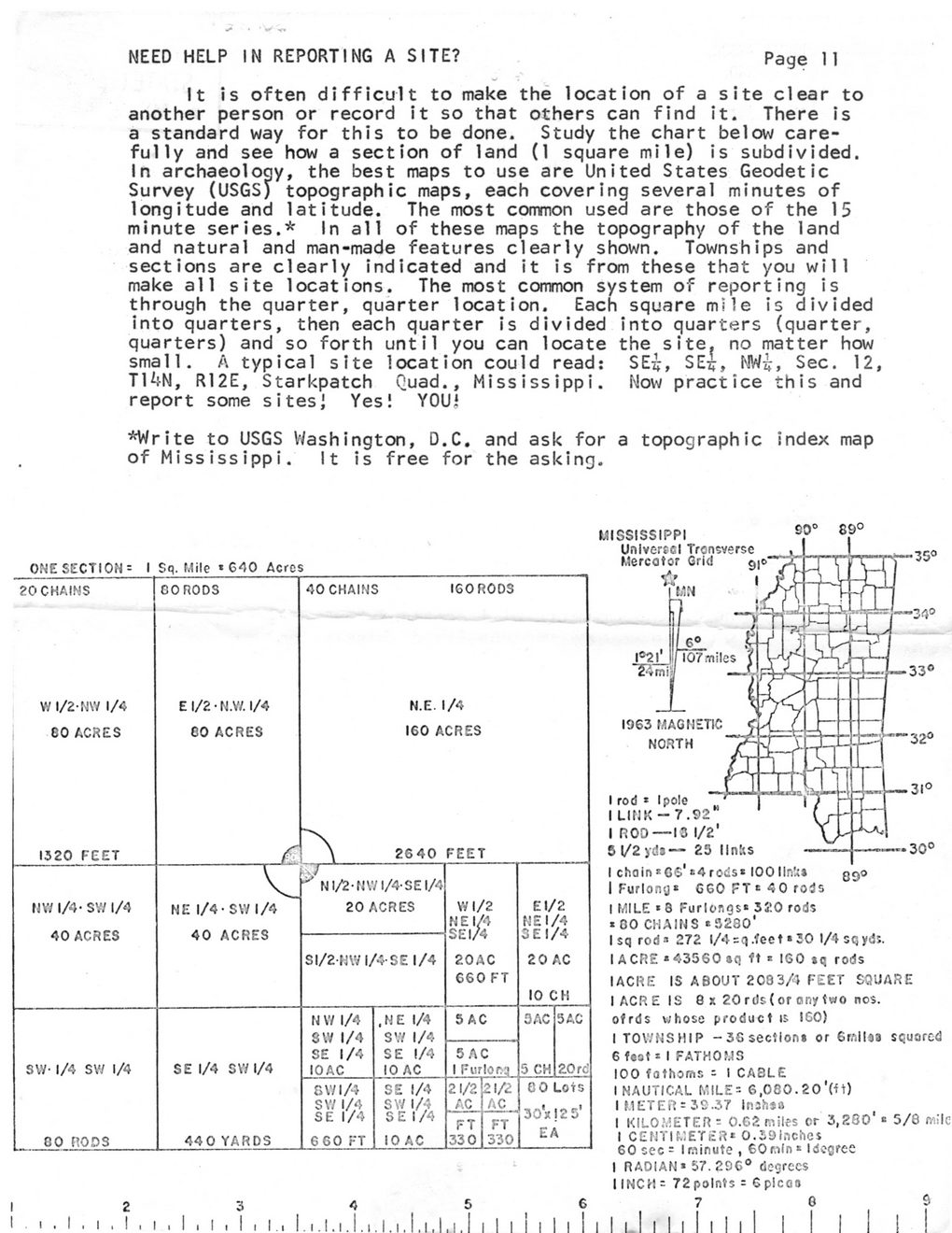
NEED HELP IN REPORTING A SITE?
Page 11
It is often difficult to make the location of a site clear to another person or record it so that others can find it. There is a standard way for this to be done. Study the chart below carefully and see how a section of land (1 square mile) is subdivided.
In archaeology, the best maps to use are United States Geodetic Survey (USGS) topographic maps, each covering several minutes of longitude and latitude. The most common used are those of the 15 minute series.* In all of these maps the topography of the land and natural and man-made features clearly shown. Townships and sections are clearly indicated and it is from these that you will make all site locations. The most common system of reporting is through the quarter, quarter location. Each square mile is divided into quarters, then each quarter is divided into quarters (quarter, quarters) and so forth until you can locate the site, no matter how small. A typical site location could read:	SEi, SE^, NW?, Sec. 12,
T14N, R12E, Starkpatch Quad., Mississippi. Now practice this and report some sitesi Yes! YOUi
*Write to USGS Washington, D.C. and ask for a topographic index map of Mississippi. It is free for the asking.
ONE SECTION: I Sq. Mile * 640 Acrcs
20 CHAINS
W 1/2-N\Y 1/4 EO ACRES
1320 FEET
NY/1/4- SVV 1/4 40 ACRES
SW- 1/4 SW 1/4
80 RODS
OORODS
E 1/2 ? N.W. 1/4 CO ACRES
40 CHAINS
160 RODS
N.E. 1/4 160 ACRES
2640 FEET
NE 1/4- SW 1/4 40 ACRES
^ N1/2-NW1/4-SEI/4 20 ACRES
SE 1/4 SW 1/4
440 YARDS
SI/2MVI/4SE 1/4
N W 1/4 8\V 1/4 SE 1/4 10 AC	.NE 1/4 SW 1/4 SE 1/4 10 AC	5 AC
		SAC 1 Furloftq
GW1/4	SE 1/4	21/2	21/2
SW 1/4	SW 1/4	AC	AC
SE 1/4	SEI/4	FT	FT
6 60 FT	10 AC	330	330
W 1/2 N E 1/4 SEI/4
20 AC 660 FT
El/2 NEI/4 3 El/4
2 0 AC 10 CH
SAC SAC
5 CH 20 rd
0 0 Lots
30*! 2 5' EA
MISSISSIPPI
Unlvercel Trcnsverse Mercator Grid	g|0
ft...	?
89?
09?
1963 MAGNETIC NORTH
I rod * I pole I LINK - 7.92 I ROD?13 1/2'
5	1/2 yd* ? 23 links
I chain *GS* *4 rods* 100 Unit*
I Furlong* 660 FT * 40 rods I MILE *8 Furlongs* 320 rods * 00 CHAINS *3230'
I sq rod* 272 1/4 =q.feet * 30 1/4 sqyds.
I A CRE * 43560 ?q ft * 160 *q rods I ACRE IS ABOUT 2083/* FEET SQUARE I ACRE IS 8 x 20 rds (or any two nos. ofrds whose product is 160)
I TOWNSHIP -36 section* or 6mil*a squared
6	f?st * I FATHOMS
100 fathoms =? I CABLE I NAUTICAL MILE * 6,080. 20'(*t)
I METER = 30.37 Injhsa
I KILOMETER = 0.62 miles or 3,260' * 5/8 mile I CENTIMETER* O.S9lnches 60 sec = I minute , 60nln * I degree I RADIAN* 57. 296? degrees I INCH = 72 points = 6 pi can
7	8	9
Walden 018